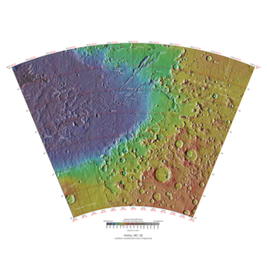
Hellas quadrangle
The Hellas quadrangle is one of a series of 30 quadrangle maps of Mars used by the United States Geological Survey (USGS) Astrogeology Research Program . The Hellas quadrangle is also referred to as MC-28 (Mars Chart-28). [1] The Hellas quadrangle covers the area from 240° to 300° west longitude and 30° to 65° south latitude on the planet Mars . Within the Hellas quadrangle lies the classic features Hellas Planitia and Promethei Terra . Many interesting and mysterious features have been discovered in the Hellas quadrangle, including the giant river valleys Dao Vallis, Niger Vallis, Harmakhis, and Reull Vallis—all of which may have contributed water to a lake in the Hellas basin in the distant past. [2] [3] [4] Many places in the Hellas quadrangle show signs of ice in the ground, especially places with glacier-like flow features.
Page Revisions
| Year | Metadata | Sections | Top Words | First Paragraph |
| 2018 |
383440 characters 25 sections 221 paragraphs 200 images 322 internal links 137 external links |
6. Climate change caused ice-rich features 9. Evidence for possible recent liquid water |
hiwish 0.566 hirise 0.419 program 0.303 view 0.217 hellas 0.190 layers 0.188 ice 0.166 close 0.121 glacier 0.110 polygons 0.106 reull 0.089 tongue 0.081 terrain 0.074 layered 0.073 pits 0.068 |
The Hellas quadrangle is one of a series of 30 quadrangle maps of Mars used by the United States Geological Survey (USGS) Astrogeology Research Program . The Hellas quadrangle is also referred to as MC-28 (Mars Chart-28). [1] The Hellas quadrangle covers the area from 240° to 300° west longitude and 30° to 65° south latitude on the planet Mars . Within the Hellas quadrangle lies the classic features Hellas Planitia and Promethei Terra . Many interesting and mysterious features have been discovered in the Hellas quadrangle, including the giant river valleys Dao Vallis, Niger Vallis, Harmakhis, and Reull Vallis—all of which may have contributed water to a lake in the Hellas basin in the distant past. [2] [3] [4] Many places in the Hellas quadrangle show signs of ice in the ground, especially places with glacier-like flow features. |
| 2017 |
347288 characters 24 sections 186 paragraphs 170 images 319 internal links 123 external links |
6. Climate change caused ice-rich features 9. Evidence for possible recent liquid water |
hiwish 0.562 hirise 0.408 program 0.302 hellas 0.203 view 0.188 ice 0.163 layers 0.146 glacier 0.131 polygons 0.127 close 0.110 tongue 0.096 reull 0.085 pits 0.081 terrain 0.081 dust 0.071 |
The Hellas quadrangle is one of a series of 30 quadrangle maps of Mars used by the United States Geological Survey (USGS) Astrogeology Research Program . The Hellas quadrangle is also referred to as MC-28 (Mars Chart-28). [1] The Hellas quadrangle covers the area from 240° to 300° west longitude and 30° to 65° south latitude on the planet Mars . Within the Hellas quadrangle lies the classic features Hellas Planitia and Promethei Terra . Many interesting and mysterious features have been discovered in the Hellas quadrangle, including the giant river valleys Dao Vallis, Niger Vallis, Harmakhis, and Reull Vallis—all of which may have contributed water to a lake in the Hellas basin in the distant past. [2] [3] [4] Many places in the Hellas quadrangle show signs of ice in the ground, especially places with glacier-like flow features. |
| 2016 |
215231 characters 19 sections 111 paragraphs 107 images 299 internal links 38 external links |
6. Climate change caused ice-rich features |
hiwish 0.436 hirise 0.342 hellas 0.312 program 0.238 ice 0.202 glacier 0.198 reull 0.144 tongue 0.114 view 0.114 layers 0.109 tilt 0.106 layered 0.101 dust 0.095 vallis 0.091 mantle 0.091 |
The Hellas quadrangle is one of a series of 30 quadrangle maps of Mars used by the United States Geological Survey (USGS) Astrogeology Research Program . The Hellas quadrangle is also referred to as MC-28 (Mars Chart-28). [1] The Hellas quadrangle covers the area from 240° to 300° west longitude and 30° to 65° south latitude on the planet Mars . Within the Hellas quadrangle lies the classic features Hellas Planitia and Promethei Terra . Many interesting and mysterious features have been discovered in the Hellas quadrangle, including the giant river valleys Dao Vallis, Niger Vallis, Harmakhis, and Reull Vallis—all of which may have contributed water to a lake in the Hellas basin in the distant past. [2] [3] [4] Many places in the Hellas quadrangle show signs of ice in the ground, especially places with glacier-like flow features. |
| 2015 |
176096 characters 17 sections 72 paragraphs 68 images 271 internal links 38 external links |
6. Climate change caused ice-rich features |
hellas 0.414 ice 0.268 hirise 0.206 hiwish 0.200 reull 0.191 glacier 0.155 tilt 0.141 dust 0.125 vallis 0.121 unit 0.120 program 0.116 basin 0.111 debris 0.098 mantle 0.098 plains 0.098 |
The Hellas quadrangle is one of a series of 30 quadrangle maps of Mars used by the United States Geological Survey (USGS) Astrogeology Research Program . The Hellas quadrangle is also referred to as MC-28 (Mars Chart-28). [1] The Hellas quadrangle covers the area from 240° to 300° west longitude and 30° to 65° south latitude on the planet Mars . Within the Hellas quadrangle lies the classic features Hellas Planitia and Promethei Terra . Many interesting and mysterious features have been discovered in the Hellas quadrangle, including the giant river valleys Dao Vallis, Niger Vallis, Harmakhis, and Reull Vallis—all of which may have contributed water to a lake in the Hellas basin in the distant past. [2] [3] [4] Many places in the Hellas quadrangle show signs of ice in the ground, especially places with glacier-like flow features. |
| 2014 |
146513 characters 13 sections 47 paragraphs 47 images 262 internal links 36 external links |
5. Climate change caused ice-rich features |
hellas 0.494 reull 0.252 ice 0.211 glacier 0.184 hirise 0.173 vallis 0.160 tilt 0.155 hiwish 0.139 dust 0.122 basin 0.102 mantle 0.101 apron 0.098 image 0.095 features 0.094 debris 0.091 |
The Hellas quadrangle is one of a series of 30 quadrangle maps of Mars used by the United States Geological Survey (USGS) Astrogeology Research Program . The Hellas quadrangle is also referred to as MC-28 (Mars Chart-28). [1] The Hellas quadrangle covers the area from 240° to 300° west longitude and 30° to 65° south latitude on the planet Mars . Within the Hellas quadrangle lies the classic features Hellas Planitia and Promethei Terra . Many interesting and mysterious features have been discovered in the Hellas quadrangle, including the giant river valleys Dao Vallis, Niger Vallis, Harmakhis, and Reull Vallis—all of which may have contributed water to a lake in the Hellas basin in the distant past. [2] [3] [4] Many places in the Hellas quadrangle show signs of ice in the ground, especially places with glacier-like flow features. |
| 2013 |
144357 characters 13 sections 47 paragraphs 46 images 262 internal links 36 external links |
5. Climate change caused ice-rich features |
hellas 0.494 reull 0.252 ice 0.211 glacier 0.184 hirise 0.173 vallis 0.160 tilt 0.155 hiwish 0.139 dust 0.122 basin 0.102 mantle 0.101 apron 0.098 image 0.095 features 0.094 debris 0.091 |
The Hellas quadrangle is one of a series of 30 quadrangle maps of Mars used by the United States Geological Survey (USGS) Astrogeology Research Program . The Hellas quadrangle is also referred to as MC-28 (Mars Chart-28). [1] The Hellas quadrangle covers the area from 240° to 300° west longitude and 30° to 65° south latitude on the planet Mars . Within the Hellas quadrangle lies the classic features Hellas Planitia and Promethei Terra . Many interesting and mysterious features have been discovered in the Hellas quadrangle, including the giant river valleys Dao Vallis, Niger Vallis, Harmakhis, and Reull Vallis—all of which may have contributed water to a lake in the Hellas basin in the distant past. [2] [3] [4] Many places in the Hellas quadrangle show signs of ice in the ground, especially places with glacier-like flow features. |
| 2012 |
136127 characters 12 sections 44 paragraphs 44 images 259 internal links 36 external links |
hellas 0.488 reull 0.279 glacier 0.203 hirise 0.191 vallis 0.177 hiwish 0.154 ice 0.150 basin 0.113 apron 0.109 image 0.106 debris 0.101 water 0.099 program 0.097 dust 0.096 7152 0.089 |
The Hellas quadrangle is one of a series of 30 quadrangle maps of Mars used by the United States Geological Survey (USGS) Astrogeology Research Program . The Hellas quadrangle is also referred to as MC-28 (Mars Chart-28). [1] |
|
| 2011 |
83436 characters 12 sections 43 paragraphs 37 images 112 internal links 30 external links |
hellas 0.496 reull 0.295 hirise 0.191 glacier 0.191 vallis 0.188 hiwish 0.146 ice 0.132 basin 0.120 apron 0.115 image 0.112 debris 0.106 water 0.105 program 0.094 lda 0.094 lobate 0.094 |
The Hellas quadrangle is one of a series of 30 quadrangle maps of Mars used by the United States Geological Survey (USGS) Astrogeology Research Program . The Hellas quadrangle is also referred to as MC-28 (Mars Chart-28). [1] |
|
| 2010 |
59507 characters 11 sections 39 paragraphs 30 images 104 internal links 9 external links |
hellas 0.507 reull 0.330 vallis 0.209 hirise 0.154 basin 0.134 apron 0.128 debris 0.119 water 0.117 ice 0.108 lda 0.105 lobate 0.105 dust 0.103 penticton 0.099 themis 0.096 deposits 0.096 |
The Hellas quadrangle is one of a series of 30 quadrangle maps of Mars used by the United States Geological Survey (USGS) Astrogeology Research Program . The Hellas quadrangle is also referred to as MC-28 (Mars Chart-28). [1] |
|
| 2009 |
45331 characters 10 sections 25 paragraphs 22 images 91 internal links 8 external links |
hellas 0.383 reull 0.369 vallis 0.226 ice 0.138 lda 0.134 lobate 0.134 water 0.132 dust 0.131 penticton 0.126 themis 0.123 lineated 0.121 mantle 0.120 hadriaca 0.115 vapor 0.106 hirise 0.106 |
The Hellas quadrangle covers the area from 240° to 300° west longitude and 30° to 65° south latitude on the planet Mars . Within the Hellas quadrangle lies the classic features Hellas Planitia and Promethei Terra . Many interesting and mysterious features have been discovered in the Hellas quadrangle. Dao Vallis, a giant river valley, formed near Hadriaca Patera, an the old volcano. |